Submerged Aquatic Vegetation (SAV)
Sustain and increase the habitat benefits of submerged aquatic vegetation (SAV) in the Chesapeake Bay. Achieve and sustain the ultimate outcome of 185,000 acres of SAV Bay-wide necessary for a restored Bay. Progress toward this ultimate outcome will be measured against a target of 90,000 acres by 2017 and 130,000 acres by 2025.
Progress
Recent Progress: Decrease
The Virginia Institute of Marine Science (VIMS) reported 82,778 acres of underwater grasses in the Chesapeake Bay and its tributaries in 2024. This is 64% of the Chesapeake Bay Program’s 130,000-acre restoration target and 45% of its 185,000-acre goal. It is a 112% increase from the 38,958 acres observed during the first underwater grass survey in 1984, but a 1% decrease from the 83,419 acres reported in 2023.
Outlook: Off Course
The Submerged Aquatic Vegetation (SAV) Outcome is off course because it is unlikely that the 2025 target of 130,000 acres will be met. Simultaneous increases and decreases in different regions of the Bay resulted in little net change in total SAV coverage between 2023 and 2024. These contrasting changes across the system reflect the way geography, land use and local environmental conditions combine to shape the overall status of SAV in the Bay each year.
Submerged Aquatic Vegetation (SAV) Abundance (1984-2024)
Factors such as adverse weather conditions, water clarity and security restrictions over military air space have prevented researchers from collecting aerial imagery. For these unmapped areas, estimates of SAV acreage are based on the prior year’s survey. Data was not collected in 1988.
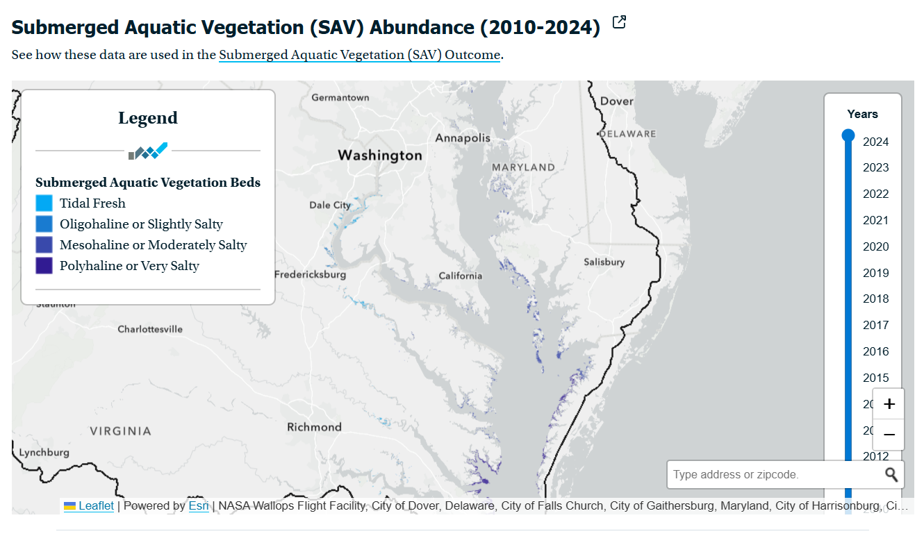
Submerged Aquatic Vegetation (SAV) Abundance (2010-2024)
Between 2023 and 2024, the Bay’s Tidal Fresh, Oligohaline (slightly salty), and Polyhaline (very salty) salinity zones showed increases in SAV. The Mesohaline (moderately salty) Zone showed a decrease.
- Tidal Fresh Zone: Underwater grass beds increased from 19,823 acres to 20,218 acres, a 98% achievement of the region’s 20,602-acre goal.
- Oligohaline Zone (Slightly Salty): Underwater grass beds increased from 3,422 acres to 4,730 acres, a 46% achievement of the region’s 10,334-acre goal.
- Mesohaline Zone (Moderately Salty): Underwater grass beds decreased from 38,371 acres to 33,031 acres, a 27% achievement of the region’s 120,306-acre goal.
- Polyhaline Zone (Very Salty): Underwater grass beds increased from 21,803 acres to 24,800 acres, a 74% achievement of the region’s 33,647-acre goal.
Increases in the Oligohaline Zone were driven by underwater grass recoveries in multiple areas, including the Sassafras, Gunpowder, and Back and Middle rivers, as well as a rise in observed SAV in the Potomac River. Increases in the Polyhaline Zone were observed in all segments, with the largest gains occurring in Mobjack Bay, Poquoson Flats and the nearby Western Shore. In fact, this is the most SAV reported in the Polyhaline Zone in the history of the underwater grass survey, surpassing the previous record set in 1993 by 784 acres. These Polyhaline gains build on a pattern of year after year increases since the 2019 crash and an extension of the region’s eelgrass meadows into deeper waters, which may indicate improved water clarity in this area of the Bay.
In contrast, the Mesohaline Zone experienced a 14% decline, which largely occurred in the Choptank and Little Choptank rivers and Tangier Sound. The declines in the Choptank mirror declines in the river’s water quality. and highlight the relationship between water quality and SAV within the Bay. Declines in Tangier Sound may be connected.
In 2024, high-density beds accounted for 65% of the Bay’s total acreage, which is 3% higher than 2023. The density classifications for the beds in 2024 are as follows:
- 2% of the beds had densities of <10% (Class 1)
- 10% of the beds had densities of 10-40% (Class 2)
- 24% of the beds had densities of 40 -70% (Class 3)
- 65% of the beds had densities of 70-100% (Class 4)
Underwater grass beds are critical to the Bay ecosystem. They provide food and shelter to fish and wildlife, sequester carbon and buffer coastal acidification, add oxygen to the water, absorb nutrient pollution, reduce shoreline erosion and help suspended particles of sediment settle to the bottom. Because they are sensitive to pollution but quick to respond to water quality improvements, underwater grass abundance is a good indicator of the Bay’s health.
Review of photographic evidence from several sites dating back to 1937 suggests that between 200,000 to 600,000 acres of SAV may have once grown along the shoreline of the Bay. However, by 1984, that number had fallen to a low of about 38,000 acres. Research has shown that nutrient reductions made under the Chesapeake Bay Total Maximum Daily Load (Bay TMDL) have played a critical role in the overall underwater grass recovery documented since the Bay-wide aerial survey began in 1984. But these nutrient reductions have not been adequate to improve water clarity to the extent necessary for SAV goal attainment. Continued and accelerated nutrient reductions are necessary to facilitate future SAV recovery. Environmental changes and sediment loading from shoreline alteration and land use changes will also continue to impact restoration success. Thus education, outreach, regulation, investment and application of restoration science will continue to be critical to managing climatic and societal stressors, alongside accelerated nutrient reductions.
More information about underwater grass abundance in the Bay can be found on the Virginia Institute of Marine Science (VIMS) website.
Management Strategy
To achieve this outcome, Chesapeake Bay Program partners have committed to:
- Supporting efforts to conserve and restore current and future underwater grass habitat and habitat conditions.
- Protecting existing and recovering underwater grasses.
- Restoring underwater grasses.
- Enhancing underwater grass research and monitoring.
- Enhancing community involvement, education and outreach.
These partners will also collaborate with the work being done to achieve the 2025 Watershed Implementation Plans (WIPs) and Water Quality Standards Attainment and Monitoring outcomes.
Monitoring and assessing progress toward the outcome will occur through analysis of data related to underwater grass distribution and abundance.
As part of the Chesapeake Bay Program’s partnership-wide implementation of adaptive management, progress toward this outcome was reviewed and discussed by the Management Board in December of 2023.
Logic & Action Plan
Chesapeake Bay Program partners have committed to taking a series of specific actions that will support the management approaches listed above.
Ongoing
- Monitoring submerged aquatic vegetation throughout the Chesapeake Bay and its tidal tributaries through the Bay-wide aerial survey, the Chesapeake Bay SAV Watchers program, and the SAV Sentinel Site Program.
- Tracking advancements in the scientific understanding of underwater grass biology, ecology, genetics, restoration and other related topics.
- Encouraging local, state and federal partners to manage those invasive species that are detrimental to underwater grasses.
- Supporting the Water Quality Goal Implementation Team (GIT) in its efforts to achieve water clarity standards in areas designated for submerged aquatic vegetation use.
- Convening quarterly, in-person meetings of the Submerged Aquatic Vegetation Workgroup to discuss priorities, review status updates and implement work plan actions.
- Working to review and implement appropriate recommendations from the 2019 SAV Regulatory Review that protect underwater grasses in the Chesapeake Bay.
- Continuing efforts to expand SAV restoration activities: establish underwater grass beds through direct seeding where they are not recovering naturally and adding diversity to grass beds that have already recovered; use these restoration activities to engage and educate citizen volunteers and further our understanding of site selection criteria; distribute the recently completed SAV Restoration Guide; work with permitting agencies to ensure SAV restoration activities are permitted during appropriate growing conditions and to prevent over-harvesting from donor aquatic grass beds.
- Encouraging local, state and federal partners to consider and promote the habitat benefits and ecosystem services of underwater grasses.
- Assessing and promoting the use of best management practices (BMPs) that benefit the persistence and recovery of underwater grass beds.
- Determining the local effect of flow and stormwater runoff on SAV density and acreage and options for targeting best management practices (BMPs) that would protect priority SAV areas.
- Reviewing potential opportunities to create a Chesapeake Bay SAV nursery or SAV nursery network.
- Developing a communication strategy that enhances the public's knowledge of and appreciation for SAV in Chesapeake Bay.
Recently Completed
2022-2023
- Held and published a report on the Scientific and Technical Advisory Committee (STAC) Rising Watershed and Bay Water Temperatures Workshop, which evaluated the potential impact of increasing water temperatures on SAV restoration and its ability to provide relevant ecosystem services.
- Completed and published the results of Modeling the Past to Predict the Future: Forecasting the Relative Role of Climate Change and Habitat Management on Chesapeake Bay SAV, which evaluated the attainability of SAV restoration targets in the face of changing environmental conditions.
- Published SAV Monitoring Program webpages on ChesapeakeBay.net.
- Identified and prioritized an updated list of SAV science and research needs.
- Identified funding opportunities to support the continued exploration of satellite imagery and the development of algorithms and workflows to automate SAV detection and quantification.
- Continued implementation of the SAV Watchers Program and worked to identify funding opportunities to ensure the program’s long-term stability.
- Finalized the SAV Sentinel Site monitoring protocol and developed an implementation plan for the monitoring program that includes identification and commitment from site adopters.
Participating Partners
The Submerged Aquatic Vegetation Workgroup, which is part of the Vital Habitats Goal Implementation Team leads the effort to achieve this outcome. It works in partnership with the Sustainable Fisheries and Water Quality goal implementation teams.
Participating partners include:
- Maryland Department of Natural Resources (State of Maryland)
- Maryland Department of the Environment (State of Maryland)
- Virginia Coastal Zone Management Program
- Virginia Department of Environmental Quality (Commonwealth of Virginia)
- Virginia Marine Resource Commission
- D.C.’s Department of Energy and Environment (District of Columbia)
- U.S Environmental Protection Agency
- Virginia Institute of Marine Science (Commonwealth of Virginia)
- University of Maryland Center for Environmental Science (State of Maryland)
- St. Mary’s College of Maryland
- Old Dominion University
- Smithsonian Environmental Research Center
- Tetra Tech, Inc.
- Chesapeake Bay Foundation
- The Nature Conservancy
- U.S. Fish and Wildlife Service
- U.S. Geological Survey
- National Oceanic and Atmospheric Administration
- U.S Army Corps of Engineers
- U.S. Fish and Wildlife Service
- National Oceanic and Atmospheric Administration
- U.S. Geological Survey
- U.S. Army Corps of Engineers
- Local Riverkeepers and Watershed Organizations